Module 1: Patna, Banka, Nalanda, Buxar and Bhojpur
Concept
Subtopic 1.1: Patna to Bhojpur
These notes follow the printed district tables. Population, density, the 2001–11 growth rate, sex ratio and literacy are the Census 2011 figures printed in those tables. A formation year is the year printed beside that row. A row the table leaves out is not filled in from anywhere else.
Patna
- Headquarters: Patna
- Area: 3,202 sq km
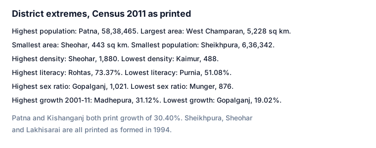
- Population: 58,38,465 (highest-population district)
- Density (2011): 1,823
- Growth (2001–11): 30.40%
- Sex ratio (2011): 897
- Literacy (2011): 70.68%
- Male literacy: 78.48%
- Female literacy: 61.96%
- Bordering districts: Vaishali, Samastipur, Begusarai, Lakhisarai, Nalanda, Jehanabad, Arwal, Bhojpur and Saran
- Lok Sabha seats: 2
- Subdivisions: Barh, Danapur, Masaurhi, Paliganj, Patna City, Patna Sadar
- Blocks: 23
- Gram panchayats: 331
- Crops: rice, potato, onion, vegetables
- Industry: sugar, welding, biscuit, flour mill, electric bulbs, shoes, baigan, glass
- Rivers: Ganga, Son, Punpun
Banka
- Headquarters: Banka
- Formed: 1991
- Area: 3,019.34 sq km
- Population: 20,34,763
- Density (2011): 674
- Growth (2001–11): 26.48%
- Literacy (2011): 58.17%
- Male literacy: 67.62%
- Female literacy: 47.66%
- Subdivisions: 3: Belhar, Rajwan and Banka
- Blocks: 11
- Gram panchayats: 158
- Crops: sugarcane, rice, wheat; Rajwan, Shambhuganj
- Industry: sugar industry
- Rivers: Chanan, Belharni, Barua, Orhni, Chheer
Nalanda
- Headquarters: Bihar Sharif
- Formed: 1972
- Area: 2,367 sq km
- Population: 28,77,653
- Density (2011): 1,222
- Growth (2001–11): 21.39%
- Sex ratio (2011): 922
- Literacy (2011): 64.43%
- Male literacy: 74.86%
- Female literacy: 53.10%
- Assembly seats: 7
- Subdivisions: Bihar Sharif, Rajgir, Hilsa
- Blocks: 20
- Crops: rice, potato, onion
- Industry: handloom, bidi
Buxar
- Headquarters: Buxar
- Formed: 11 March 1991
- Area: 1,703 sq km
- Population: 17,06,352
- Density (2011): 1,002
- Growth (2001–11): 21.67%
- Sex ratio (2011): 922
- Literacy (2011): 70.14%
- Male literacy: 80.72%
- Female literacy: 58.63%
- Bordering districts: Bhojpur, Rohtas and Kaimur
- Assembly seats: 4
- Subdivisions: Buxar, Dumraon
- Crops: rice, wheat, maize, sugarcane
Bhojpur
- Headquarters: Ara
- Formed: 1992
- Area: 2,395 sq km
- Population: 27,28,407
- Density (2011): 1,139
- Growth (2001–11): 21.63%
- Sex ratio (2011): 907
- Literacy (2011): 70.74%
- Male literacy: 81.74%
- Female literacy: 58.03%
- Bordering districts: Patna, Arwal, Rohtas, Buxar and Saran
- Subdivisions: Ara Sadar, Jagdishpur, Piro
- Patna, 58,38,465, is marked the highest-population district. Density 1,823. Female literacy 61.96%.
- Banka was formed in 1991. Area 3,019.34 sq km. Blocks 11 and 158 gram panchayats.
- Nalanda headquarters is Bihar Sharif, formed 1972, with 20 blocks and 7 assembly seats.
- Buxar is dated 11 March 1991. Bhojpur, headquarters Ara, is dated 1992.
- Question: Which district is marked as having the highest population? Answer: Patna.
- Question: What is the Census 2011 density printed for Patna? Answer: 1,823.
- Question: Where is the headquarters of Nalanda? Answer: Bihar Sharif.
- Question: On what date was Buxar formed, as printed? Answer: 11 March 1991.
MCQs
Answer this question, then use Next.
Question 1: Which district table calls that district the one with the highest population?
Question 2: What Census 2011 density is printed for Patna?
Question 3: In which year does the table place the formation of Banka?
Question 4: What is the printed headquarters of Nalanda?
Question 5: On which date does the table place the formation of Buxar?
Question 6: What is the printed headquarters of Bhojpur?
One-liners
Write your answer, then submit to see the correct answer.
Which district is marked as having the highest population?
Patna.What is the Census 2011 density printed for Patna?
1,823.Where is the headquarters of Nalanda?
Bihar Sharif.On what date was Buxar formed, as printed?
11 March 1991.