Module 1: Kosi Project and Power House
Concept
Subtopic 1.1: Kosi Project: Overview
- Bihar has three major river valley projects: the Kosi project & power house, the Son barrage scheme and the Gandak project. All three were brought under the Command Area Development Programme (CADP) in 1974 and belong to the state government.
- The Kosi project is the main multipurpose project of North Bihar, completed at a cost of ₹86 crore. Before it, about 3200 ha of farmland (as printed) suffered from the Kosi's shifting course and floods.
- It was established in 1953; the India-Nepal agreement was reached in April 1954.
- It was completed in 1965 and modified in 1966; the Hanuman Nagar barrage and embankments were built under it.
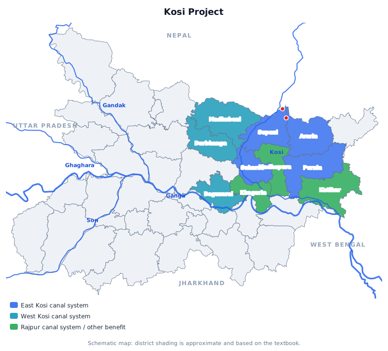
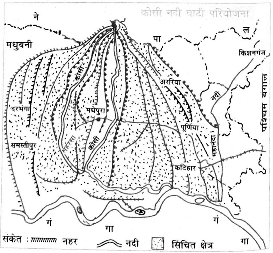
- The East Kosi, West Kosi and Rajpur canals were built, making irrigation of 3.14 lakh ha possible, and a hydro-power house was set up at Kataiya (near Birpur).
- Kosi, Son and Gandak were brought under the Command Area Development Programme in 1974.
- The Kosi project cost ₹86 crore.
- Agreement came in April 1954; the project was established in 1953 and completed in 1965.
- The power house is at Kataiya near Birpur.
- East Kosi, West Kosi and Rajpur canals, irrigating 3.14 lakh ha.
- It was completed in 1965 and modified in 1966.
- Question: In which year were Bihar's three river valley projects brought under the CADP? Answer: 1974.
- Question: At what cost was the Kosi project completed? Answer: ₹86 crore.
- Question: When was the India-Nepal agreement on the Kosi project reached? Answer: April 1954.
- Question: Where is the Kosi project's hydro-power house located? Answer: Kataiya (near Birpur).
- Question: Which three canals were built under the Kosi project? Answer: East Kosi, West Kosi, Rajpur.
- Question: In which year was the Kosi project completed? Answer: 1965.
MCQs
Answer this question, then use Next.
Question 1: In which year were Bihar's three river valley projects brought under the CADP?
Question 2: At what cost was the Kosi project completed?
Question 3: When was the India-Nepal agreement on the Kosi project reached?
Question 4: Where is the Kosi project's hydro-power house located?
Question 5: Which three canals were built under the Kosi project?
Question 6: In which year was the Kosi project completed?
One-liners
Write your answer, then submit to see the correct answer.
In which year were Bihar's three river valley projects brought under the CADP?
1974.At what cost was the Kosi project completed?
₹86 crore.When was the India-Nepal agreement on the Kosi project reached?
April 1954.Where is the Kosi project's hydro-power house located?
Kataiya (near Birpur).Which three canals were built under the Kosi project?
East Kosi, West Kosi, Rajpur.In which year was the Kosi project completed?
1965.Concept
Subtopic 1.2: Hanuman Nagar Barrage and Flood Embankments
- About 45 km south of the Chatra gorge in Nepal's terai, a barrage 1149 m long and 72 m high was built near Bhimnagar; it is known as the Hanuman Nagar Kosi barrage.
- Embankments of 2458 m to Bharda (right) and 1895 m to Bhimnagar (left) were built near it. Maximum discharge is 11.9 thousand kl/min on the right and 28.9 thousand kl/min on the left.
- Earthen flood embankments run parallel to the river to fix the Kosi's shifting course: Bharda to Ghonghepur ~124 km (right) and Bhimnagar to Kopariya 146 km (left).
- A ring bund protects Nirmali; a 13 km control bund runs from Bharda to Bhikundi; a 32 km afflux bund from Bhimnagar to Bandhjora created a 41 km submerged area beside the barrage.
- The Mahadev, Maru, Dalwa and Nirmali embankments protect about 2.65 lakh ha from floods, but about 1 lakh ha of about 300 villages between the two main embankments is flooded every year.
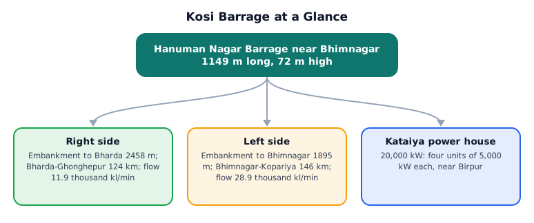
- The barrage near Bhimnagar is 1149 m long and 72 m high.
- It lies about 45 km south of the Chatra gorge in Nepal's terai.
- Left bank: Bhimnagar-Kopariya 146 km; right bank: Bharda-Ghonghepur about 124 km.
- About 2.65 lakh ha is protected, though ~1 lakh ha of ~300 villages between the embankments still floods.
- A ring bund protects Nirmali from floods.
- Left bank 28.9 thousand kl/min; right bank 11.9 thousand kl/min.
- Question: What are the length and height of the Hanuman Nagar (Kosi) barrage? Answer: 1149 m long, 72 m high.
- Question: How far south of the Chatra gorge is the Kosi barrage? Answer: 45 km.
- Question: What is the length of the left-bank flood embankment from Bhimnagar to Kopariya? Answer: 146 km.
- Question: About how much area do the Kosi embankments protect from floods? Answer: 2.65 lakh ha.
- Question: Which town is protected by a ring bund under the Kosi project? Answer: Nirmali.
- Question: What is the maximum discharge on the left bank of the Hanuman Nagar barrage? Answer: 28.9 thousand kl/min.
MCQs
Answer this question, then use Next.
Question 1: What are the length and height of the Hanuman Nagar (Kosi) barrage?
Question 2: How far south of the Chatra gorge is the Kosi barrage?
Question 3: What is the length of the left-bank flood embankment from Bhimnagar to Kopariya?
Question 4: About how much area do the Kosi embankments protect from floods?
Question 5: Which town is protected by a ring bund under the Kosi project?
Question 6: What is the maximum discharge on the left bank of the Hanuman Nagar barrage?
One-liners
Write your answer, then submit to see the correct answer.
What are the length and height of the Hanuman Nagar (Kosi) barrage?
1149 m long, 72 m high.How far south of the Chatra gorge is the Kosi barrage?
45 km.What is the length of the left-bank flood embankment from Bhimnagar to Kopariya?
146 km.About how much area do the Kosi embankments protect from floods?
2.65 lakh ha.Which town is protected by a ring bund under the Kosi project?
Nirmali.What is the maximum discharge on the left bank of the Hanuman Nagar barrage?
28.9 thousand kl/min.Concept
Subtopic 1.3: Kosi Canal Systems and Kataiya Power House
- Kosi canals on both banks serve about 26 lakh ha in Saharsa, Supaul, Purnia, Araria, Katihar, Darbhanga, Madhubani and Khagaria, and in Saptari district of Nepal. They form three systems: East Kosi, West Kosi and Rajpur.
- The East Kosi canal leaves the left bank and irrigates 5.69 lakh ha of Purnia, Araria, Supaul and Saharsa. The main canal is only 43.5 km, but with branches (Murliganj, Janakinagar, Purnia, Araria) it totals 3,038 km. Its Phulkaha distributary irrigates about 12,000 ha near the Nepal border.
- The West Kosi canal leaves the right bank to irrigate about 3.10 lakh ha of Darbhanga and Begusarai and 28,000 ha of Saptari, through 113 km of canals. The Chatra canal near Baghjora (Nepal) irrigates 85,890 ha of Begusarai, and the West Kosi canal 28,300 ha of Saptari.
- The Rajpur canal leaves the left bank, between the East Kosi canal and the eastern flood embankment. One branch (Rajpur) and four sub-branches (Madhepura, Gamharia, Saharsa, Supaul) total 366 km, irrigating about 4 lakh ha of Saharsa and Begusarai freed from floods.
- A 20,000 kW hydro-power house at Kataiya has four units of 5,000 kW each.
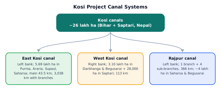
- The East Kosi canal irrigates 5.69 lakh ha of Purnia, Araria, Supaul and Saharsa.
- The main canal is 43.5 km, but with branches it totals 3,038 km.
- The West Kosi canal leaves the right side; East Kosi and Rajpur leave the left.
- One branch and four sub-branches total 366 km, irrigating about 4 lakh ha.
- 20,000 kW, from four units of 5,000 kW each.
- Saptari district of Nepal benefits (28,000 ha via the West Kosi canal).
- The Chatra canal irrigates 85,890 ha of Begusarai.
- The Phulkaha distributary irrigates about 12,000 ha.
- Question: How much land does the East Kosi canal irrigate every year? Answer: 5.69 lakh ha.
- Question: What is the total length of the East Kosi canal including its branches? Answer: 3,038 km.
- Question: From which bank of the Hanuman Nagar barrage does the West Kosi canal leave? Answer: Right.
- Question: What is the total length of the Rajpur canal system? Answer: 366 km.
- Question: What is the capacity of the Kataiya hydro-power house? Answer: 20,000 kW.
- Question: Which Nepalese district also benefits from the Kosi canals? Answer: Saptari.
- Question: The Chatra canal (near Baghjora, Nepal) irrigates how much land in Begusarai? Answer: 85,890 ha.
- Question: Which distributary of the East Kosi canal irrigates about 12,000 ha near the Bihar-Nepal border? Answer: Phulkaha.
MCQs
Answer this question, then use Next.
Question 1: How much land does the East Kosi canal irrigate every year?
Question 2: What is the total length of the East Kosi canal including its branches?
Question 3: From which bank of the Hanuman Nagar barrage does the West Kosi canal leave?
Question 4: What is the total length of the Rajpur canal system?
Question 5: What is the capacity of the Kataiya hydro-power house?
Question 6: Which Nepalese district also benefits from the Kosi canals?
Question 7: The Chatra canal (near Baghjora, Nepal) irrigates how much land in Begusarai?
Question 8: Which distributary of the East Kosi canal irrigates about 12,000 ha near the Bihar-Nepal border?
One-liners
Write your answer, then submit to see the correct answer.
How much land does the East Kosi canal irrigate every year?
5.69 lakh ha.What is the total length of the East Kosi canal including its branches?
3,038 km.From which bank of the Hanuman Nagar barrage does the West Kosi canal leave?
Right.What is the total length of the Rajpur canal system?
366 km.What is the capacity of the Kataiya hydro-power house?
20,000 kW.Which Nepalese district also benefits from the Kosi canals?
Saptari.The Chatra canal (near Baghjora, Nepal) irrigates how much land in Begusarai?
85,890 ha.Which distributary of the East Kosi canal irrigates about 12,000 ha near the Bihar-Nepal border?
Phulkaha.