Module 1: Water Resources of Bihar
Concept
Subtopic 1.1: Importance of Water and the Drainage Regions
- Water matters most for drinking, irrigation and hydro-power; it is also needed for industry, fisheries, transport, recreation and conserving other life.
- In Bihar's river basins there is a close inter-relation between groundwater and surface water.
- North of the Ganga there are eight main drainage regions: Ghaghara, Gandak, Burhi Gandak, Bagmati, Adhwara, Kamla, Kosi and Mahananda.
- In the South Bihar plain there are seven main drainage regions: Karmanasa, Son, Punpun, Kiul, Harohar, Badua-Chandan and Chir, besides smaller Ganga tributaries.
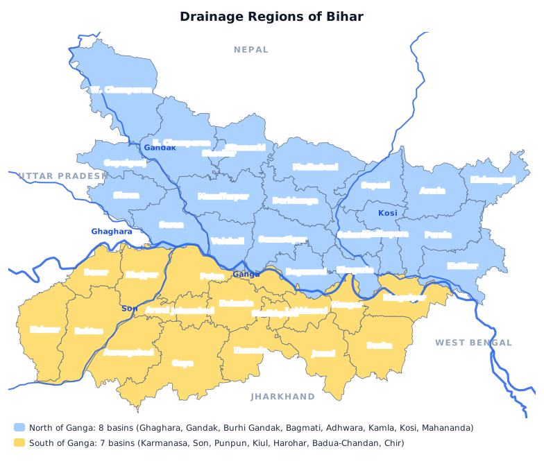
- North of the Ganga there are eight: Ghaghara, Gandak, Burhi Gandak, Bagmati, Adhwara, Kamla, Kosi, Mahananda.
- South Bihar has seven: Karmanasa, Son, Punpun, Kiul, Harohar, Badua-Chandan, Chir.
- Harohar is a South Bihar basin; Adhwara, Kamla and Mahananda are north of the Ganga.
- Water is most important for drinking, irrigation and hydro-power.
- Question: How many main drainage regions lie north of the Ganga in Bihar? Answer: Eight.
- Question: How many main drainage regions lie in the South Bihar plain? Answer: Seven.
- Question: Which river basin belongs to South Bihar, not North Bihar? Answer: Harohar.
- Question: Water as a resource is most important for which uses? Answer: Drinking water, irrigation and hydro-power.
MCQs
Answer this question, then use Next.
Question 1: How many main drainage regions lie north of the Ganga in Bihar?
Question 2: How many main drainage regions lie in the South Bihar plain?
Question 3: Which river basin belongs to South Bihar, not North Bihar?
Question 4: Water as a resource is most important for which uses?
One-liners
Write your answer, then submit to see the correct answer.
How many main drainage regions lie north of the Ganga in Bihar?
Eight.How many main drainage regions lie in the South Bihar plain?
Seven.Which river basin belongs to South Bihar, not North Bihar?
Harohar.Water as a resource is most important for which uses?
Drinking water, irrigation and hydro-power.Concept
Subtopic 1.2: Groundwater Resources
- Bihar's water potential has been assessed by the State Groundwater Organisation and the Geological Survey Department; surface and groundwater are unevenly distributed.
- In the alluvial plain, 20-22% of total rainfall recharges groundwater.
- The Central Groundwater Board estimates an average gradient of 20 m per km in Darbhanga; annual supply there is fixed at 886 crore cubic metres.
- Siwan has 248 crore cubic metres of groundwater a year; 229 medium-to-heavy and 1600 shallow tube-wells can be built there.
- To raise irrigation intensity in the plains (to over 2.5 times the net sown area), maximum use of groundwater is desirable. Farmers have long stored rain in tanks, ahar and pyne.
- In the Ganga plain, groundwater is the main source of irrigation.
- 20 to 22% of total rainfall recharges groundwater.
- Siwan has 248 crore cubic metres a year; Darbhanga's figure is 886 crore.
- 1600 shallow and 229 medium-to-heavy tube-wells can be built in Siwan.
- The Central Groundwater Board estimated 20 m/km in Darbhanga.
- Groundwater is the main source of irrigation in the Ganga plain.
- Question: What share of total rainfall recharges groundwater in Bihar's alluvial plain? Answer: 20-22%.
- Question: How much groundwater is available each year in Siwan district? Answer: 248 crore cu m.
- Question: How many shallow tube-wells can be built in Siwan district? Answer: 1600.
- Question: In which district is the average hydraulic gradient estimated at 20 m per km? Answer: Darbhanga.
- Question: What is the main source of irrigation in the Ganga plain? Answer: Groundwater.
MCQs
Answer this question, then use Next.
Question 1: What share of total rainfall recharges groundwater in Bihar's alluvial plain?
Question 2: How much groundwater is available each year in Siwan district?
Question 3: How many shallow tube-wells can be built in Siwan district?
Question 4: In which district is the average hydraulic gradient estimated at 20 m per km?
Question 5: What is the main source of irrigation in the Ganga plain?
One-liners
Write your answer, then submit to see the correct answer.
What share of total rainfall recharges groundwater in Bihar's alluvial plain?
20-22%.How much groundwater is available each year in Siwan district?
248 crore cu m.How many shallow tube-wells can be built in Siwan district?
1600.In which district is the average hydraulic gradient estimated at 20 m per km?
Darbhanga.What is the main source of irrigation in the Ganga plain?
Groundwater.